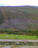
 Looking across to Cairndow
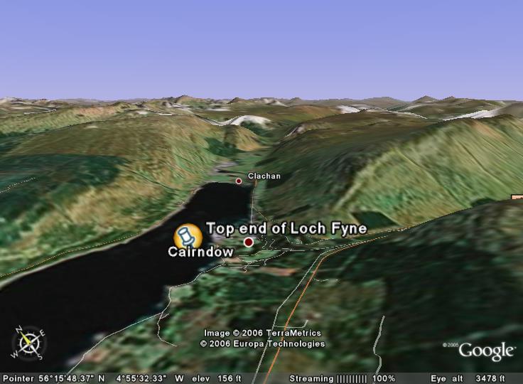 Find the area on google earth if you have it. I'll put the placemark up later
 Here is the O.S. map you will need to use
OK, a little homework, primarily aimed at s3, but open to s4/5/6 as well I suppose. I am going to pose a few questions, and basically, I just want students to use the comments function to add their thoughts. It is really about using map evidence and sources, very common in exams
1) Using the sources available, describe the physical features of the landscape surrounding Ardkinglas/Cairndow.
2) Again, using the sources (remember the map), what are the main land uses in this area?Give reasons as to why you think the area is suitable for the land uses you identify.
3) Describe fully the land use conflicts which may exist in an area such as this-the image at the top was taken using a mobile phone, but if you look closely, there are clues to some of the conflicts.
Loads to come on this blog, but haven't had the time to put all your work on yet. In the next week or so, I hope to have the following:-
s1-Audio Weather reports
s2 Unzen reports-An audio report from John, and a powerpoint slide with audio clips from various members of the class. Also, got some video clips to upload from students talking about their Japan leaflets.
s3 Limestone post-it-open in www.classtools.net
s4-Maybe a couple of paragraphs from some of the Call Centres essays, useful revision for the upcoming assessment

19 comments:
Mr O'D says-You can leave a comment now without having a profile. Fire away!
Watersports could be a land use here because there is a large body of water readily available.-18
Thanks for commenting, 18, let's keep the comments coming!
it has steep mountains around and in winter could be used for skiing and snowboarding
for conflics there might be one in farming and tourists(tourists being the cars) there is a main road right beside the sheep in the picture taken by mobile phone cars might come down fast and startle them.
the phisical features of the landscape are, they is lots of rivers or water coming down the mountains and the mountains are quite steep. there is alot of forestry around and farming as we can see from the sheep in mobile picture. it might be a tourist place because of the viewpoints.
ill try and find more points
-4
Thanks. Some points to consider...It is a glaciated upland, look for some familiar features-are there any pyr peaks, truncated spurs etc-think about some of the features that you learned about in class.
one of the conflicts could be between tourism and farming as the tourists could leave the farm gates open which could lead to the animals escaping and getting hurt.
(10)
Conflicts between tourists and farmers are:
> Tourists could trample on vegetation.
> Tourists may leave litter causing animals to eat it.
> Tourists could cause footpath erosion by constantly walking on the grass.
<19>
Tourism and Farming conflicts (20) :-
* People not following the country
code
* they can leave gates open which can can let animals out - stray animals can wander onto roads and be killed or cause accidents
* walkers can leave litter and farm animals can eat the litter and become sick
* Visitors can bring dogs to the country which can worry farm animals especially sheep and lambs
*they may trample vegitation untill they cause footpath erosion.
* tourists drive to the country which will block the country rodes which the farmers will undoubtably want to use
Tourism and Farming
-Gates being left opened by walkers
-Trampling of vegetation
- Litter
-Footpath erosion
-Toursit with pets
(13)
There are hotels and tourist facilities near farmland which would cause conflicts between tourists and farmers :
1) tourists leaving gates open
2) dropping litter and possibly harming animals
also,
There is a road running right through the forestry and maybe the farmland which locals and farmers wouldn't be happy about.
I can see you are all thinking well about the conflicts-what about the physical landscape from the O.S. map-what about the contours etc, what kind of features are they showing? Keep this going, I am pleased with the response!
possible land uses in ardinglas could be:
-water sports
-hill climbing
-rock climbing
-hand gliding
-sightseeing
-skiing/snowboarding(in winter)
-sheep farming
-camping
-quarrying
Land use conflicts-quarrying,tourists:
-noise pollution: machinery
-visual pollution: dust, machinery
-congestion: slow machinery will block and damage roads
...:::7:::...
1) Glaciated upland, Y shaped valley, hanging valley, Ribbon Lake, in the far background it looks like a pyramidal peak, arêtes. – Google earth picture!
2) Forestry, corries, pyramidal peak, arêtes, maybe ribbon lake.- Map picture
2) Water sports: could be a major land use here because of the large river.
Hill walking, climbing or mountain biking: due to the many hills surrounding the river.
Snow boarding or skiing: In the background of the Photo there are many snow topped hill - Picture Google earth!
Farming, Tourism, watersports, climbing, businesses, and sightseeing- map picture
3) Conflicts between tourism and farmers
- Leaving gates open when exploring and leaving the farmers animals to leave the area.
- Creating vegation
- Footpath erosion
- Dropping litter, which could be eaten by the animals
- Tourists could be annoyed at the farmers keeping them out
- Also the many roads might cause a inconvenience or the farmers
Conflicts between Tourism and Locals
- Many locals will up their prices due to business annoying tourists
- Locals land will be more expensive as the tourists will buy holiday houses there making the place more popular
- Tourists attract more tourists making the place overcrowded
- Locals lose out on jobs as tourists may get a semi-permanent one while they are staying in the area
NUMBER 1
conflict between hill walkers and military testing can cause problems,the hill climbers are there for the peace and tranquility and they wouldn't like a jet racing over their head.NO.3
it would be good for hill walking and winter sports becuase the hills around are perfect.it is also a good place for boating-no 23
- suitable for almost all types of water sports - river
- climbing or walking activites - mountain, big rocks and open grass land
- farming - animals and grass
- vegetation - fields and moisture from the nearby river
.29.
In the first picture, you can see that you can do a couple of different activities.You can:-
* Do water sports
* Sight see
* Hill walk
Some of the conflicts in the Cairndow are as follows:-
* Cars may frighten sheep if they go fast whilst going past them.
* Tourist may trample on vegetation.
* Tourists may leave litter and the animals could eat it by accident.
* Tourists may often leave gates open and animals can them walk out onto the road.
..:: 09 ::..
Conflicts between tourists and farmers are : tourists can trample on vegetation.
tourists could have a pet who scares the animals and runs at them if not keep on a lesh.
tourists could leave gates open and resulting in animals escaping.
tourists can drop litter.
tourists can trample on the land causing it to erode.
22
Large V-shaped valley, Glaciated upland, arétes, big loch..
This area could be almost perfect for all kinds of water sports, and also good for activities such as hillwalking,sightsee-ing or pargliding etc.
A lot of conflicts could be held in an area like this- like with tourist and farmers;
o Tourists leave gates open and may alow animals to escape
o leave litter around and harm animals
o erode and destroy the landscape by treading over precious land
Numero 15! (i think)
Post a Comment