OK, another online activity, this time for s4, but bear in mind this is Higher's next topic. I have been flicking back through an old Developments magazine, a freebie that the dept for International Development send me now and again, and have come up with this:-
Country A
A vast country, this nation is extremely rich in natural resources such as diamonds, cassiterite(for tin) and gold. It also has large areas of fertile agricultural land and borders several countries which could possibly be trade partners. From 1960, the country received 30 years of intensive investment from abroad, and the country and capital have hosted some high profile international events. Recently, nurses and teachers have been on strike in this location, and there have been riots in the capital city. The currency is also losing value.
Country B
This country has experienced nearly half a century of dicatorship, a decade of conflict, and before that was a colony of a small European country. It has courted controversy for its indifference to Human rights abuses in a neighbouring country. Here is the location of some of the world's most extensive rainforest, but people earn the equivalent of 27 cents per day, and 1000 people a day die of hunger. Hopes are high for the future after plans for a $50 billion Hydro-electric project were unveiled
Here is your task
a) Which is the most developed country and why?
b) Bonus marks if you can guess the country in the examples
Use the evidence, but also look for anything which doesn' quite fit about both examples...
Monday, November 27, 2006
Thursday, October 26, 2006
Higher Rivers Collaboration
 This one's for Higher. Click on the picture above and you should then see a short video clip with a commentary from one of your peers. It's a good start, but is there anything else that could have been said about a) the river channel; b) the river valley; c) the processes at work in this stage of the river and d) the impact of the surrounding area on the hydrograph for this river-think maybe about different times of year? I will also set up another clip in class, which we can get some commentary on, and we'll do the same. Leave a comment by clicking below
Sunday, October 22, 2006
Glaciated Landscapes-A class task
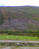 Looking across to Cairndow
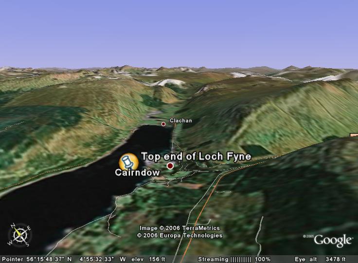 Find the area on google earth if you have it. I'll put the placemark up later
 Here is the O.S. map you will need to use
OK, a little homework, primarily aimed at s3, but open to s4/5/6 as well I suppose. I am going to pose a few questions, and basically, I just want students to use the comments function to add their thoughts. It is really about using map evidence and sources, very common in exams
1) Using the sources available, describe the physical features of the landscape surrounding Ardkinglas/Cairndow.
2) Again, using the sources (remember the map), what are the main land uses in this area?Give reasons as to why you think the area is suitable for the land uses you identify.
3) Describe fully the land use conflicts which may exist in an area such as this-the image at the top was taken using a mobile phone, but if you look closely, there are clues to some of the conflicts.
Loads to come on this blog, but haven't had the time to put all your work on yet. In the next week or so, I hope to have the following:-
s1-Audio Weather reports
s2 Unzen reports-An audio report from John, and a powerpoint slide with audio clips from various members of the class. Also, got some video clips to upload from students talking about their Japan leaflets.
s3 Limestone post-it-open in www.classtools.net
s4-Maybe a couple of paragraphs from some of the Call Centres essays, useful revision for the upcoming assessment
Monday, September 11, 2006
Here we go....
This is the blog I was talking to some of the sudents about. We can now start displaying some examples of your work on here. I will post on odblog to tell you about any upcoming displays.
Subscribe to:
Posts (Atom)
