 This one's for Higher. Click on the picture above and you should then see a short video clip with a commentary from one of your peers. It's a good start, but is there anything else that could have been said about a) the river channel; b) the river valley; c) the processes at work in this stage of the river and d) the impact of the surrounding area on the hydrograph for this river-think maybe about different times of year? I will also set up another clip in class, which we can get some commentary on, and we'll do the same. Leave a comment by clicking below
Thursday, October 26, 2006
Higher Rivers Collaboration
 This one's for Higher. Click on the picture above and you should then see a short video clip with a commentary from one of your peers. It's a good start, but is there anything else that could have been said about a) the river channel; b) the river valley; c) the processes at work in this stage of the river and d) the impact of the surrounding area on the hydrograph for this river-think maybe about different times of year? I will also set up another clip in class, which we can get some commentary on, and we'll do the same. Leave a comment by clicking below
Sunday, October 22, 2006
Glaciated Landscapes-A class task
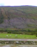
 Looking across to Cairndow
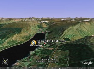
 Find the area on google earth if you have it. I'll put the placemark up later
 Here is the O.S. map you will need to use
OK, a little homework, primarily aimed at s3, but open to s4/5/6 as well I suppose. I am going to pose a few questions, and basically, I just want students to use the comments function to add their thoughts. It is really about using map evidence and sources, very common in exams
1) Using the sources available, describe the physical features of the landscape surrounding Ardkinglas/Cairndow.
2) Again, using the sources (remember the map), what are the main land uses in this area?Give reasons as to why you think the area is suitable for the land uses you identify.
3) Describe fully the land use conflicts which may exist in an area such as this-the image at the top was taken using a mobile phone, but if you look closely, there are clues to some of the conflicts.
Loads to come on this blog, but haven't had the time to put all your work on yet. In the next week or so, I hope to have the following:-
s1-Audio Weather reports
s2 Unzen reports-An audio report from John, and a powerpoint slide with audio clips from various members of the class. Also, got some video clips to upload from students talking about their Japan leaflets.
s3 Limestone post-it-open in www.classtools.net
s4-Maybe a couple of paragraphs from some of the Call Centres essays, useful revision for the upcoming assessment
